
Tags
Battle of Brooklyn, Blockhouse No. 1, British Army, Central Park, Central Park Conservancy, Fort Clinto, General George Washington, General Henry Knox, Harlem Meer, Kips Bay, McGown's Pass, New York City, Nutter's Battery, Revolutionary War, War of 1812
“Lost History” Blog Series
 I did quite a bit of research in an around New York City’s Central Park for my young adult (YA) novel. I was amazed by the history there, some of which is all but lost. The stories I uncovered were so fascinating, I’ve decided to do a blog series on them.
The Lost History blog series isn’t connected to my YA novel, except for the Central Park location. These are stories rich in character that deserved to be told and remembered. [image: morguefile.com]
The Revolutionary War in Central Park?
It’s hard to think of present-day Manhattan as anything but the leader in finance, theater, art, fashion and other trends for the nation, if not the world. Yet, if you venture into Central Park to the top of the bluffs south of the Harlem Meer, on the winding paths amidst the craggy promontories … you’ll be standing where history was made in America’s Revolutionary War.
 The Revolutionary War in Central Park?
I admit, I was somewhat dumbfounded when I first learned this fact. It was as incongruous as dinosaur bones beneath Los Angeles (in tar pits beneath La Brea Avenue).
Before Central Park was built, the land east of the bluffs was marshy and impassable. Travelers on their way to New York City had to follow a narrow gorge through the bluffs. A path that was originally an Indian trail.
This path later became known as McGown’s Pass (sometimes called McGowan’s Pass), after the family that owned a nearby tavern. McGown’s Tavern is another bit of Lost History I’ll share with you in another post.
This 1776 map shows McGown’s Pass and Kingsbridge Road, around the start of the British Occupation. [image: Wikipedia]
McGown’s Pass: Strategic High-Ground
After General George Washington’s defeat at the Battle of Brooklyn (1776), he moved most of his troops north through McGown’s Pass. Then on the morning of September 15, 1776, British troops landed in Kips Bay (near present-day 34th Street), staged for an invasion. Washington, who was headquartered at the Morris Mansion on West 160th Street, lead his troops south through McGown’s Pass to counter the invading forces.
Washington and his troops were outnumbered, and retreated to the west. The British Army held McGown’s Pass and built a fortification there, so as to control the troops that went in and out of the city. When the Revolutionary War ended seven years later, colonial soldiers (under the command of General Henry Knox) marched back through McGown’s Pass, and into Manhattan to liberate the city.

McGown’s Pass circa 1868, image: Wikipedia
The Blockhouse and The War of 1812
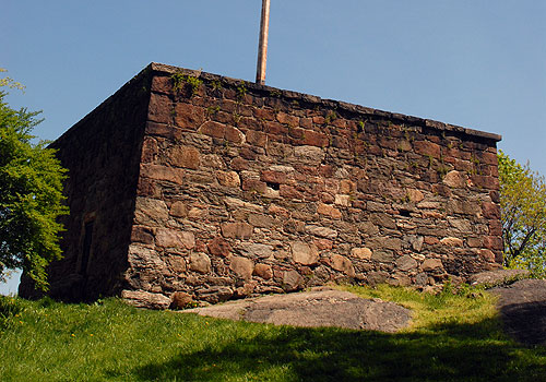 Remembering the earlier (British) occupation of McGown’s Pass, Americans claimed it as a lookout point during the War of 1812, in anticipation of another British invasion. A series of fortifications were built at this tme, including Blockhouse No. 1 (remains are still visible on a hill in the North Woods), Fort Clinton, and Nutter’s Battery (remains of these are visible along the north side of the pass). Four-foot high defensive walls (breastworks) made of earth were created to connect the fortifications. However, the British never invaded. [image: Central Park Conservancy]
The Blockhouse stands high on “The Cliff” and is Central Park’s oldest building. At one time, the square stone structure had a sunken wooden roof and mobile cannon. Today the Blockhouse is empty, roofless and securely locked.
The following map shows present-day McGown’s Pass and Blockhouse locations in Central Park. East Drive follows the original path through the McGown’s Pass.

McGown’s Pass is a reminder of the role New York City played in the history of the American Republic.
Happy 4th of July!


Awesome post. It’s amazing how much serious history sits beneath our feet – this is true over here in New Zealand too. And amidst the modern buildings, parks and structures with which we’ve transformed our world, we just never think about it.
One of the most incongruous sites in New Zealand is Te Ngutu o Te Manu (‘The Beak of the Bird’), in the 1860s deep within dense forest, a pa (fortified village) belonging to the chief Titokowaru. Several battles were fought there. Today? It’s a Hawera Town Council camping ground. I am not kidding. There is a small plinth off to one side revealing its past history – which, I bet, hardly anybody notices. Or if they do, they don’t care.
Thanks, Matthew. I wasn’t interested in history in high school, because of the way it was taught. Then I studied art in college, and discovered the correlation between what was happening in a given period of history and the art. History suddenly became personal. That’s what you’re doing with the books you write, making history personal.
Fascinating stuff! I love learning about lost bits of history. Central Park is one of the best things about NYC. I’m looking forward to your future posts on one of my favorite cities.
Thank you, Tami. Central Park is one of my favorite places too. The men who designed the park were ahead of their time when it came to urban planning. The Central Park Conservancy offers a variety of free guided tours, that I’ve yet to take advantage of. Next visit, for sure!
http://www.centralparknyc.org/visit/tours/guided-tours/
Belated happy fourth of july elizabeth!
Thank you! A belated 4th to you too. I love fireworks any day of the year!